
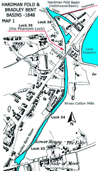
The Phantom Lock
The Hollinwood Branch Canal had eight locks but historical sources record that it only had seven.
An examination of the official Western Canal Distance Tables published by the Manchester, Sheffield and Lincolnshire Railway Company (MS&LR) in September 1888 shows that the
Hollinwood Branch Canal had seven locks. The top lock on the mainline of the Ashton Canal was numbered 18, so these seven locks were numbered sequentially, 19, 20, 21, 22, 23 24 and 25.
Similarly, Bradshaw's Canals and Navigable Waterways of England and Wales also listed seven locks but in this publication they were numbered 1 to 7. The table below compares the locations of these locks from a
datum at Fairfield Junction on the Ashton Canal.
| Actual Lock No. | MS&LR and (Bradshaw) Lock No. | MS&LR Location from Datum | Bradshaw Location from Datum |
|---|---|---|---|
| Miles Yards | Miles Yards | ||
| 19 | 19 (1) | 2 880 | 2 880 |
| 20 | 20 (2) | 2 968 | Not given |
| 21 | 21 (3) | 2 990 | Not given |
| 22 | 22 (4) | 2 1,078 | 2 1,100 |
| 23 | 23 (5) | 4 440 | 4 440 |
| 24 | 24 (6) | 4 638 | 4 660 |
| 25 | — | Phantom Lock | Phantom Lock |
| 26 | 25 (7) | 4 1,012 | 4 1,000 |
The reason for the discrepancies in distances is that Bradshaw's were rounded to the nearest furlong (220 yards) whereas the MS&LR's were rounded to the nearest chain (22 yards). It is likely that the compilers of Bradshaw's Guide obtained their details from the canal owners, as they would be physically unable to inspect every canal in the country, and in this instance this was from the Great Central Railway Company, the later name of the MS&LR. For this reason, Bradshaw's Guide showed the Hollinwood Branch Canal as having seven locks instead of eight, as did Hadfield and Biddle's book, Canals of North West England, Volume 2.
The chambers of the first four locks at Waterhouses are still extant so they can be counted and there are four of them. The mystery surrounding Phantom Lock concerns the locks between Bradley Bent Basin and Hardman Fold Basin (aka Hollinwood Basin). Were there three locks or four? All trace of these locks has long since been destroyed but there is ample evidence to show that there were, indeed, four in spite of the fact that official records of the MS&LR list only three. Where was Phantom Lock located and why was it 'air brushed' out of official records? The first question can be answered but the second one cannot.
Regrettably, confirmation of the existence of the Phantom Lock (Lock 25) does not explain why it was 'air brushed' away but it is difficult to believe that the MS&LR surveyors simply walked by without noticing that it was there. Could it be that the canal here was a sensitive issue with the MS&LR and that they did not wish to draw too much attention to it? Was the situation such that it was expedient to 'air brush' lock 25 out of existence for legal reasons that are now unknown? It is now too distant in time for the truth to be revealed but it could be connected with events discussed below.
Unauthorised Canal Extension
Construction of the Manchester, Ashton-under-Lyne and Oldham Canal, to give it its full name, was authorised by five Acts of Parliament.
32 George III cap. 84 Royal Assent 11 Jun 1792 33 George IIIcap 21, Royal Assent 28 Mar 1793 38 George III cap 32, Royal Assent 26 May 1798 39 & 40 George III cap 24, Royal Assent 16 May 1800 45 George III cap 11, Royal Assent 18 Mar 1805
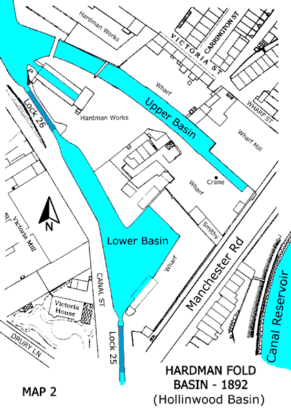
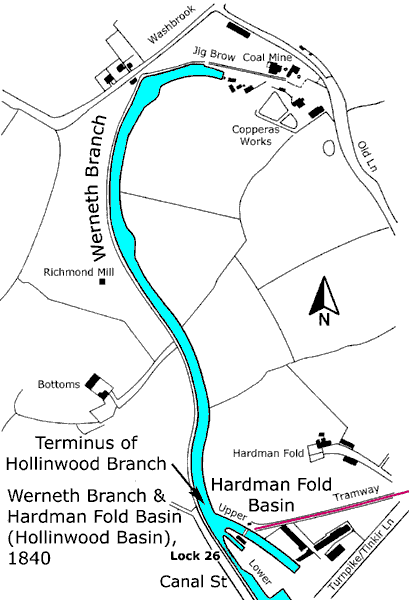
Thomas Brown, the surveyor, produced a plan in 1793 that showed the Parliamentary terminus of the Hollinwood Branch Canal to be at Bradley Bent on Hollinwood Common. Similarly, the plan accompanying the 1793 Bill showed the terminus to be at Bradley Bent. The Ashton Canal Company had a problem with this in that it did not reach a suitable water supply and neither did it reach a profitable coal mine a short distance to the north. Anyway, the Hollinwood Branch was extended beyond its Parliamentary terminus to finish at an unnamed canal basin that was sited immediately north of Manchester Rd. However, the most suitable name for this basin seems to be Hardman Fold Basin (aka Hollinwood Basin), a name taken from the adjoining hamlet of Hardman Fold. This split-level basin was comprised of Lower Hardman Fold Basin and Upper Hardman Fold Basin, with Lock 26 providing the connection between the two.
To confuse matters still further, the canal did not actually terminate at Hardman Fold Basin because it was privately extended by the Werneth Colliery Company to end near their Old Lane Colliery and a copperas works (ferrous sulphate) at Werneth. This extension was known as the Werneth Branch and the Distance Tables of the MS&LR list this extension as a Private Branch of the Chamber Colliery Company (who took over the Werneth Colliery Company). It is understood that the Werneth Branch became disused a short time before 1876 (E Keaveney and D L Brown, 1974, p.23) and that much of its course was obliterated by the construction of a railway embankment.
The implication of these details is that the 792 yards of the Hollinwood Branch between Bradley Bent Basin and its actual terminus, including locks 23, 24, 25 and 26, were unauthorised, so how did the Ashton Canal Company surmount this problem? The Werneth Colliery Company was empowered to build a branch canal, not more than four miles long, from their coal mine to an existing canal and this is precisely what they did. They constructed their private extension from their coal mine to the Parliamentary terminus of the Hollinwood Branch Canal at Bradley Bent Basin and not to the Upper Hardman Fold Basin as shown officially in the Distance Tables.
The Werneth Colliery Company did not construct this canal solely on their own initiative, as there was collusion with the Ashton Canal Company. An Ashton Canal Company report, dated 8 November 1798, reads, '···· by payments to Werneth Colliery Company in part of £4,000 the amount of their contract in building four locks (locks 23, 24, 25 and 26) purchasing land, and extending the Oldham Branch (Hollinwood Branch Canal) beyond the termination of the Parliamentary line at Hollinwood (Bradley Bent Basin) ···· £3,200.' The interpretation of this is that on this date a final annual payment of £800 still had to be made in 1799. This signifies that this section of the canal, built by the Werneth Colliery Company, was 'bought' by the Ashton Canal Company in annual instalments of £800 between 1795 and 1799. In this way the Ashton Canal Company extended the Hollinwood Branch Canal to their required termination without recourse to Parliament.
The Rochdale Canal Company, whose Act of 1794 included a branch to Hollinwood, believed that they had been hoodwinked and they sought counsel's opinion upon, '···· whether the Ashton Canal Company, under cover of the Clause for taking Water into their Canal, can extend the Navigation towards Oldham as they are now doing.' As no legal action ensued as a result of taking opinion it meant that they were advised that this extension was lawful. Possibly with the intention of making matters clearer, the Ashton Canal Company gave notice in 1797 that they would take powers to take over the Werneth Branch but this did not happen.
The total length of canal built by the Werneth Colliery Company was about 1,442 yards, well below the four miles permitted. To summarise, 792 yards of this, including four locks, was 'bought' by the Ashton Canal Company and the Werneth Colliery Company retained about 650 yards for private use, this being known as the Werneth Branch (See Map 3 below). By the time that the Distance Tables were published in September 1888, the Werneth Colliery Company had been taken over by the Chamber Colliery Company.
Jig Brow at the terminus of the Werneth Branch lies within an area of Oldham known as Werneth, which had rich coal deposits, and the Werneth Colliery Company owned a number of mines there. John and Joseph Lees, William Jones and John Evans established Werneth Colliery Company and reference to Chadderton Poor Law Rate Books shows that they held, 'Land, Wharf and Canal' at Hollinwood. These books illustrate the rise and fall of the Werneth Branch.
| Year | Gross Annual Value £ s d | Comments |
|---|---|---|
| 1847 | 18 0 0 | |
| 1858 | 24 0 0 | |
| 1862 | 24 0 0 | Including a Boat House |
| 1863 | 10 0 0 | |
| 1865 | 10 2 6 | |
| 1866 | 10 2 6 | |
| 1867 | 10 2 6 | Reduced on appeal to £1 0s 0d |
| 1867 | 1 2 6 | |
| 1868 | 1 2 6 | |
| 1869 | 1 2 6 | |
| 1871 | 1 2 6 | |
| 1873 | 1 2 6 |
The above table shows that the peak of prosperity for the Werneth Branch was reached in 1862. It then declined but held steady from 1863 until 1866, but in 1867 the annual value was reduced by just over 90% on appeal. The Werneth Branch then lingered on until 1871 but there was no entry for 1873. It can be deduced from this that commercial use of the Werneth Branch had virtually ceased by 1873, although the Distance Tables of September 1888 do make mention of its existence.
Further Reading
De Salis, Henry Rodolph, 1904. Bradshaw's Canals and Navigable Canals of England and Wales. Fleet St, London: Henry Blacklock & Co Ltd.
Hadfield, George and Biddle, Gordon, 1970. The Canals of North West England. 2 Vols. Newton Abbot: David & Charles.
Fanning, Gerry, 2000. Hollinwood Canal. Radcliffe, Manchester: Neil Richardson.
